Arctic blast expected to bring accumulating snow, near-record cold to Greater Cincinnati

Source: Frank Cezus / Getty
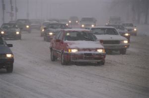
An arctic blast moves in Monday, bringing the potential for record cold, but before that, some snow.
A cold front will move in late Sunday, eventually leading to rain Monday. The morning commute remains mostly dry, but rain creeps in by lunchtime. By the afternoon, still it’s mostly rain falling. The cold quickly moves in from the northwest, causing it to switch to snow around 6 p.m. All areas should be seeing snow by 8 p.m. You will also notice a huge difference in temperatures from 3-6 p.m. We go from the 50s to the 30s in three hours!
Accumulations will generally be 1-2″, but some higher totals could be counted closer to I-70 and SE of I-71. Those totals will be closer to 2.5-3″.
Flurries linger before sunrise Tuesday, and there is a small chance of lake effect snow in the afternoon. Black ice could be problematic Tuesday morning since temperatures crash quickly. Most towns will be around 20 degrees with wind chills in the single digits.
With highs topping out around 27 degrees, it could be a day for the record books. The record lowest highest temperature for Nov. 12 is 30 degrees.
After that, a strong high pressure system takes control. If you use a humidifier, you’ll need it next week because the air is going to be incredibly dry.
Plan on cold afternoons in the 30s and 40s and bitter mornings in the 20s and colder for the rest of the week.